八方尾根Hakuba Happo-One
 丹尼斯指數Dennis Index未評分Unrated
雪場資訊Resort info

1998 年長野冬季奧運的比賽場地之一。官方:標高 760–1,831 m、最長滑走距離 8,000 m、16 條雪道、最大斜度 37°,纜車共 21 基。A venue of the 1998 Nagano Winter Olympics. Official: 760–1,831 m, longest run 8,000 m, 16 courses, maximum gradient 37°, 21 lifts and gondolas in total.
- 縣/地區Prefecture / area
- 長野縣 · 白馬村Hakuba · Nagano
- 標高/落差Elevation / vertical
- 山腳 760 m・山頂 1,831 m・垂直 1,071 mBase 760 m · top 1,831 m · vertical 1,071 m來源source
- 纜車Lifts
- 21 座21來源source
- 最長滑道Longest run
- 8 km來源source
- 2026-27 開放日2026-27 opening
- 2026-12-012026-12-01來源source
- 地形公園Terrain park
- 未整理Not compiled yet
- 票價Lift prices
- 未整理Not compiled yet
雪道圖Trail map
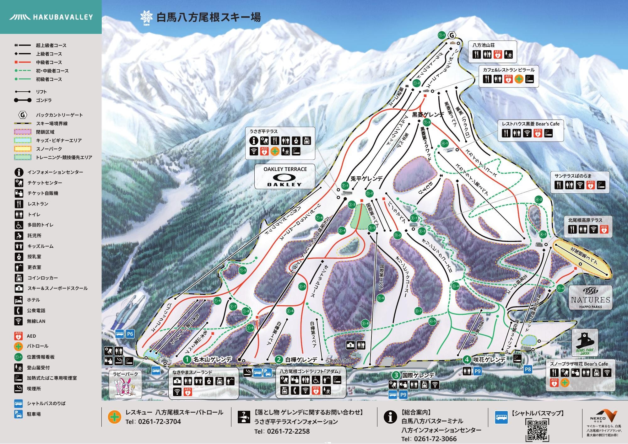 點圖看大圖Tap to enlarge
官方 PDF 轉成圖片。Converted from the official PDF.
圖片來源:雪場官方Image source: official ski field · 著作權屬各雪場,本站僅縮小轉載供參考。Copyright belongs to the resort; shown reduced for reference only.
3D 雪場地圖3D map
全螢幕 / 新分頁開啟Full screen / new tab拖曳旋轉、滾輪或雙指縮放。3D 地圖為非官方,地形與空照圖來自國土地理院地理院タイル,雪道與纜車來自 OpenSkiData(OpenStreetMap),收錄在「中部 3D 雪場地圖版本庫」(3DChubu-0001)。Drag to rotate, scroll or pinch to zoom. Unofficial 3D map: terrain and aerial photo from GSI tiles, runs and lifts from OpenSkiData (OpenStreetMap), published in the Chubu 3D library (3DChubu-0001). chubu-3d.pages.dev
出典:国土地理院(加工)・© OpenStreetMap contributors(ODbL)Source: Geospatial Information Authority of Japan (processed) · © OpenStreetMap contributors (ODbL)